While Kansas City will face dry and mild weather on Saturday, the National Weather Service warns that a strong storm system could bring severe weather, including large hail, damaging winds and tornadoes, at the beginning of the workweek.
Mostly cloudy skies will keep temperatures around 65 degrees in the metro Saturday, which is just a few degrees shy of the average of 68 for this time of year.
An area of high pressure currently over Minnesota will shift eastward throughout the day, becoming centered over the western Great Lakes area by evening, the weather service said in its forecast discussion.
The chance for showers and thunderstorms increases Saturday night, mainly south of Interstate 70, and continues into Sunday morning. No severe weather is expected.
Temperatures are expected to be in the low 70s on Sunday. According to the weather service, there will be a 50% chance of rain showers and thunderstorms in the afternoon.
Local Radar Image
Severe weather in Kansas City’s forecast
The weather service said that the focus then shifts to the potential for severe storms Monday evening and overnight.
“If storms can develop Monday afternoon/evening, they will have a higher likelihood of becoming severe,” the weather service said. The “environment would favor supercells with large hail, damaging winds and tornadoes.”
Supercells are dangerous rotating storms that resemble tall storm clouds with anvils or elongated tops, capable of producing large hail, damaging winds and tornadoes. Supercell thunderstorms can last for several hours in the right environmental conditions.
The weather service said there is some uncertainty regarding when and where the storms might develop.
The uncertainty stems from the lack of a strong weather front to help storms form and unclear wind patterns that affect storm organizations, the weather service said. Also, a cold front expected to move through the area is arriving later and not aligning with peak heating and maximum instability, which can influence the strength and timing of storms.
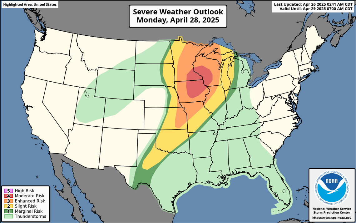
The National Weather Service’s Storm Prediction Center said severe weather outbreaks are possible over portions of the Midwest and Upper Midwest.
Kansas City, Overland Park, Omaha, Minneapolis, and Madison, Wisconsin, face an enhanced risk of severe weather, rated as level three on the Storm Prediction Center’s five-point scale.
An outbreak of severe weather is expected across the Midwest on Monday. The National Weather Service’s Storm Prediction Center has placed Kansas City and surrounding areas under an enhanced risk of severe weather, the third level on a five-point scale. Large hail, damaging winds, and tornadoes will be possible.
St. Paul, Des Moines, Cedar Rapids, Iowa, Rochester, Minnesota, and Bloomington, Minnesota, are at a moderate risk, the fourth level on the five-point scale.
Temperatures are expected to climb into the low 80s in the afternoon.
More storms are expected by Monday night as a cold front moves into the area, but the weather service said there is a lower chance for severe weather. The storms are expected to develop along the cold front, with the main threats being damaging winds and large hail.
An outbreak of severe weather is likely across portions of the Midwest and upper Midwest on Monday, according to the National Weather Service’s Storm Prediction Center. Large hail, severe wind gusts, and strong to intense tornadoes are likely. The Kansas City area is under an enhanced risk, which is the third level on five-point scale of severe weather.
Rounds of showers, thunderstorms possible
The cold front that is moving through the area overnight Monday into Tuesday morning is expected to stall just south of the area, leading to an active weather pattern through the end of the week.
Tuesday will be sunny with a high near 70 degrees.
“This front then becomes the focus for additional rounds of showers and storms,” the weather service said. “If the front stays just south of the area, the best potential for precipitation will remain south as well.”
But it looks to be close enough that the southern half of the Kansas City forecast area will continue to have a chance of rain, 25-75%, Wednesday into Thursday.
“It’s not until late in the week into the weekend that (the chances of rain) fade away,” the weather service said.


